Get FREE email communications from Fodor's Travel, covering must-see travel destinations, expert trip planning advice, and travel inspiration to fuel your passion.
Sorry! We don't have any recommendations for Alberta right now.
We’ve compiled the best of the best in Alberta - browse our top choices for the top things to see or do during your stay.
Sights
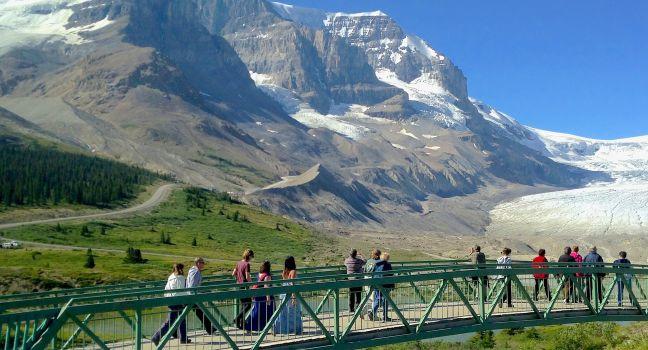
Athabasca Glacier
Fodor's choice
Lissandra Melo / Shutterstock
The glacier is a 7-km (4½-mile) tongue of ice flowing from the immense Columbia Icefield almost to the Icefields Parkway. A century ago, the ice flowed over the current location of the highway; signposts depict the gradual retreat of the ice since that time. Several other glaciers are visible from here; they all originate from the Columbia Icefield, a giant alpine lake of ice covering 325 square km (125 square miles). Its edge is visible from the highway. You can hike up to the toe of the glacier, but venturing farther without a trained guide is extremely dangerous because of hidden crevasses.
Athabasca Glacier Ice Walks (800/565–7547, www.icewalks.com) conducts three-, five-, and six-hour guided walks costing from C$115. Reserve a space at the Columbia Icefield Glacier Discovery Centre or through Jasper Adventure Centre (780/852–5595 or 800/565–7547, www.jasperadventurecentre.com) in Jasper. You can also visit the Glacier Skywalk, a glass-floored lookout with incredible views. Tickets for this are also available at the Discovery Centre, as well as on line.
Cave and Basin National Historic Site
Fodor's choice
Leonard Zhukovsky / Shuttestock
This site commemorates the birthplace of Canada's national parks system, which began with the protection of the Banff hot springs in 1885. You'll find restored historic buildings, a plaza, and splendid interpretive displays about Banff and the country's other national parks. An interpretive trail explains the area's geology, plant life, wildlife, and history. While walking past the cave's pools, keep an eye out for the park's most endangered species: the Banff Springs snail, which makes its home in the warm mineral waters, cannot be found anywhere else in the world. Children under age 17 enter the site for free, and combo tickets that include admission to Banff Upper Hot Springs are available.
This moderately steep 8-km (5-mile) trail will take four to six hours. Into early summer the upper section is still covered in snow and not recommended, but from mid-July to mid-August you can enjoy the carpet of wildflowers. There's also an excellent view of the Angel Glacier. Moderate.
Recommended Fodor's Video
Crypt Lake Trail
Fodor's choice
Awe-inspiring and strenuous, this 17.2-km (11-mile) round-trip trail is one of the most stunning hikes in the Canadian Rockies. Conquering the trail involves taking a boat taxi across Waterton Lake, climbing 700 meters (2,300 feet), crawling through a tunnel nearly 30 meters (100 feet) long, and scrambling across a sheer rock face. The reward, and well worth it: views of a 183-meter (600-foot) cascading waterfall and the turquoise waters of Crypt Lake. This hike was completely untouched by the wildfires of recent years. Difficult.
Dinosaur Provincial Park
Fodor's choice
Dinosaur Provincial Park encompasses 73 square km (28 square mi) of Canada's greatest badlands, as well as prairie and riverside habitats. A United Nations World Heritage Site, the park contains some of the world's richest fossil beds—dating as far back as 75 million years—including many kinds of dinosaurs. Much of the area is a nature preserve with restricted public access. Self-guided trails weave through different habitats, and a public loop road leads to two outdoor fossil displays. The Royal Tyrrell Museum Field Station has ongoing fossil excavations. Interpretive programs run daily from mid-May to early September and weekends until mid-October, but many require tickets; call for reservations. You should allow at least two full days for an in-depth experience. The campground has a food-service center.
Frank Slide Interpretive Centre
Fodor's choice
Overlooking the devastation of one of Canada's deadliest rock slides, the Frank Slide Interpretive Centre tells the tale of the night Turtle Mountain crumbled and 110-million metric tons of limestone crushed the town below. You can wander through interpretive displays and listen to the stories of survivors. Outside the museum is an overlook and an interpretive hiking trail that winds through the rubble.
Highwood Pass
Fodor's choice
At 2,227 meters (7,310 ft), this high mountain pass along Highway 40 is the highest paved road pass in Canada. It's a beautiful driving route with stunning mountain scenery and superlative hiking trails and other sites just off the top of the pass. Since the pass is located right at the tree line, this is one of the most accessible high alpine areas in the Rockies. Near the summit, you'll find the Highwood Meadows Trail, a 0.6-km (0.4-mile) accessible interpretive trail that will take you through a fragile alpine meadow. This road over Highwood Pass is closed to motor vehicles from December through mid-June. Early June is a great time for cyclists to enjoy the route without the worry of encountering motor vehicles. Watch for elk, deer, moose, bighorn sheep, grizzly and black bears as you traverse this pass.
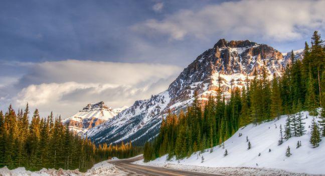
Icefields Parkway
Fodor's choice
BGSmith / Shutterstock
Powerfully rugged mountain scenery, glaciers, waterfalls and icefalls, and wildlife: the Icefields Parkway reveals all of these and more as it snakes its way along the 230 km (143 miles) connecting Banff National Park with Jasper National Park. It is an absolute highlight of the Canadian Rockies.
You could drive this winding road in three to four hours, but your trip will more likely take a full day when you add in stops. The road rises to near the tree line at several points, and the weather can be chilly and unsettled at these high elevations, even in midsummer, so it's a good idea to bring warm clothing along. Only one gas station, open seasonally, operates on the parkway, so check your car's gas gauge before setting out.
Elk, moose, deer, and bighorn sheep are fairly common, and occasionally bears and mountain goats come into view. In summer, alpine wildflowers carpet Bow Pass and Sunwapta Pass. The most dramatic scenery is in the northern end of Banff National Park and the southern end of Jasper National Park, where ice fields and glaciers become common on the high mountains flanking the parkway. (Ice fields are massive reservoirs of ice; glaciers are the slow-moving rivers of ice that flow from the ice fields.) Scenic overlooks and signposted hiking trails abound along the route.
Johnston Canyon Trail
Fodor's choice
Rushing water has carved a path through this must-see limestone canyon. The first 1.1 km (0.7 mile) is a paved walkway that leads to the 10-meter (33-foot) Lower Falls. From here, a slightly more rugged 2.7-km (1¾-mile) trail leads to the nearly 30-meter (100-foot) Upper Falls and a 5-km (3-mile) trail runs to the Ink Pots—six green pools filled with springwater. It takes four to five hours round-trip to complete. Moderate.
Maligne Lake Road
Fodor's choice
Scenic Maligne Lake Road was built along the glacier valley that runs between the Maligne and Elizabeth mountain ranges. Along the 44-km (27-mile) drive to Maligne Lake, you'll see spectacular mountain scenery, other blue lakes, and the fast-flowing Maligne River. Highlights along the way also include Maligne Canyon and Medicine Lake. This drive takes you through one of the best places to spot wildlife, especially at dusk and dawn. Look for elk, moose, bighorn sheep, white-tail deer, and grizzly and black bears.
Mount Edith Cavell
Fodor's choice
The Jasper area's highest mountain stands 3,363 meters (11,033 feet) tall. Showing its permanently snow-clad north face to the town, the peak was named for a World War I British nurse who stayed in Belgium to treat wounded Allied soldiers after Brussels fell to the Germans and was subsequently executed for helping prisoners of war escape. The mountain is arguably the most spectacular site in the park reachable by car. From Highway 93A, a narrow, winding 14½-km (9-mile) road (often closed mid-October to late June) leads to a parking lot at the mountain's base. Trailers aren't permitted on this road, but they can be left at a separate parking lot near the junction with 93A. Several scenic lookouts along the route offer access to trails leading up the Tonquin Valley, one of the premier backpacking areas.
This must-do 1.6-km (1-mile) trail only takes about an hour. The kid-friendly path, paved at the start, runs across a rocky landscape once covered in glacial ice. Eventually you come to a viewpoint overlooking Cavell Pond, which is fed by Cavell Glacier. Small icebergs often float in the water. The view across the valley takes in Angel Glacier, resting her wings between Mount Edith Cavell and Sorrow Peak. Easy.
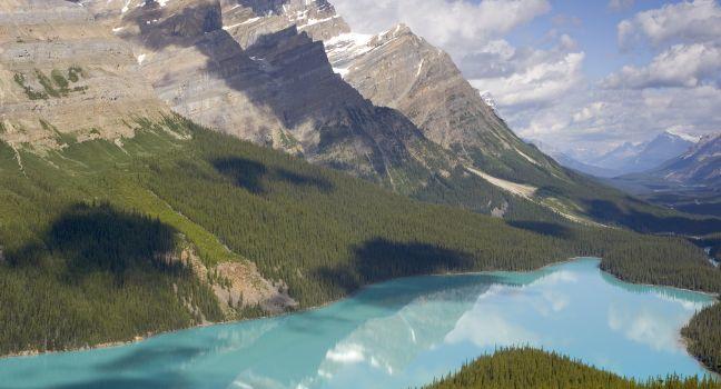
Peyto Lake Lookout
Fodor's choice
oneword / Shutterstock
Named after Bill Peyto, a mountain guide, and early park warden of Banff National Park, Peyto Lake is one of the most beautiful lakes in the Canadian Rockies. The viewpoint for this brilliant turquoise glacier-fed lake is a short 20-minute stroll from the parking area just off the Icefields Parkway. At the lookout, you'll get a view of Peyto Lake, Peyto Glacier, and the Mistaya Valley. Interpretive signage along the trail explains its history and provides information about flora and fauna in the area. The lookout is accessed at Bow Pass, the highest point on the Icefields Parkway; it's wheelchair accessible from the upper parking lot that tour buses use.
Ptarmigan Cirque
Fodor's choice
Explore the Highwood Meadows Interpretive Trail before you cross Highway 40 to begin the Ptarmigan Cirque trail. The trail leads to a high alpine meadow with incredible views of the surrounding mountains. This hike is popular with wildflower enthusiasts, especially in early to mid-July when glacier lilies blossom shortly after the snow melts. In late July to early August, more than 80 different species of wildflowers might be seen in the meadows. The hike is also popular in autumn when the larch trees turn golden before dropping their needles. The 4.5-km (2.8-mile) trail has 225 meters (700 feet) of elevation gain. Moderate.
Remington Carriage Museum
Fodor's choice
This unique museum houses the largest collection of horse-drawn vehicles in North America with over 330 carriages, buggies, wagons and sleighs. The nucleus of the collection, some 48 carriages, was donated by Don Remington, a local Cardston resident who restored and collected horse-drawn vehicles. Carriage rides are offered during the summer months for an extra charge.
Xplorer Program
Fodor's choice
Year-round, the park offers the Xplorer Program for kids age 6 to 11. Pick up an Xplorer Booklet at one of the park's visitor centers. Kids who complete at least six of the booklet's 22 activities receive a souvenir.
Abraham Lake
Alberta's largest reservoir is beautiful in every season, but it has become Instagram famous in winter when bubbles freeze in the ice---pockets of methane gas freeze in layers that coat the lake. Methane gas bubbles are formed when bacteria breaks down organic matter at the bottom of the lake. It’s a phenomenon that's found in other Rocky Mountain lakes, but it’s more visible in Abraham Lake because high winds tend to keep the ice clear of snow; January and February are peak months to view the bubbles. The manmade lake was created in 1972 with the construction of the Bighorn Dam. The lake has a surface area of 53.7 square km (20.7 square miles). Although the lake is manmade, it still has the turquoise blue color of other Rocky Mountain Lakes. Watch for bighorn sheep, black bears, and other wildlife nearby.
Adams Creek Fire Lookout
The steep 36.7-km (22.8-mile) round-trip hike to Adams Creek Fire Lookout from the Big Berland River staging area makes a nice overnight expedition in Willmore Wilderness Park. The trail has 1,369 meters (4,491 feet) of elevation gain. Difficult.
Akamina Parkway
Take this winding, 16-km (10-mile) road up to Cameron Lake, but drive slowly and watch for wildlife: it's common to see bears along the way. At the lake you will find a relatively flat, paved, 1.6-km (1-mile) trail that hugs the western shore and makes a nice walk. Bring your binoculars. Grizzly bears are often spotted on the lower slopes of the mountains at the far end of the lake.
Alberta Provincial Police Barracks
This unique museum is housed in the original Alberta Provincial Police (APP) barracks building. The APP was created during prohibition (1916-1924) to deal with "rumrunners" who were illegally importing alcohol from the United States and British Columbia. The museum tells the story of this police force, a murder, and the trial of the only woman who was ever executed in Alberta.
Allstones Lake
This moderately strenuous 13-km (8.1-mile) round-trip hike leads to a lovely alpine lake with beautiful views along the way. If you climb to the top of the peak near the lake you'll have a stunning view of Abraham Lake and the surrounding mountains. Moderate.
Angel Glacier
Stretching along the north face of Mount Edith Cavell, this glacier was named because it looks like an angel with wings. The best views of the glacier can be seen on the Cavell Meadows Hike.
Apgar
On the southwest end of Lake McDonald, this tiny village has a few stores, an ice-cream shop, motels, ranger buildings, a campground, and a historic schoolhouse. A store called the Montana House is open year-round, but except for the weekend-only visitor center, no other services remain open from November to mid-May. Across the street from the visitor center, Apgar Discovery Cabin is filled with animal posters, kids' activities, and maps.
Apgar Visitor Center
This is a great first stop if you're entering the park from the west. Here you can get all kinds of information, including maps, permits, books, and the Junior Ranger newspaper, and you can check out displays that will help you plan your tour of the park. There is a variety of ranger-led programs including free snowshoe walks in winter. Snowshoes can be rented for $2 at the visitor center.
Arethusa Cirque
Just south of Ptarmigan Cirque, this 5-km (3.1-mile) loop trail actually has more larches than its better-known neighbor. The trail begins by passing through a forested area and then opens up into a wide meadow. There's 274 meters (899 feet) of elevation gain, but it's a relatively easy hike. Easy.
Arts Commons
Downtown
The complex of four theater spaces and a state-of-the-art concert hall was pieced together in the 1980s by incorporating the historic Calgary Public Building (1930) and the Burns Building (1913). It's one of the largest arts complexes in Canada.
Astoria Valley Viewpoint
This pull-off along Cavell Road offers views of the Astoria Valley and the glaciers at its head.
Athabasca Day Use Site
This large area has a shelter and is ideal for family reunions because it can be reserved ahead for a fee of C$50. It has beautiful views of the river and mountains.
Athabasca Falls
At 23 meters (75 feet), these falls are not the highest in the Canadian Rockies, but they are the most powerful. The Athabasca River carries more water than any other in the Rocky Mountains, and all of it is funneled over this cascade and into a narrow gorge, creating a powerful surge. The falls are especially dramatic in late spring and early summer when the river is at its highest. Trails and overlooks provide good viewpoints. Do not climb past the guard rails: the rocks and vegetation are very slippery, and people have died trying to get a photo of themselves standing closer to the falls.
Avalanche Lake Trail
From Avalanche Creek Campground, take this 3-mile trail leading to mountain-ringed Avalanche Lake. The walk is only moderately difficult (it ascends 730 feet), making this one of the park's most accessible backcountry lakes. Crowds fill the parking area and trail during July and August and on sunny weekends in May and June. Moderate.
Subscribe to Newsletter
Sign up for Travel Tips & News
I want emails from Fodor's Travel with travel information and promotions. I can unsubscribe any time using the unsubscribe link at the end of all emails.
Thank you for your interest!
Look out for our newsletters with travel tips and special offers.
Sign up for Travel Tips & News
By signing up for the newsletter, I agree to the Privacy Policy. You must check the box to subscribe
Thank you for your interest!
Look out for our newsletters with travel tips and special offers.