6 Best Sights in Jasper National Park, Alberta

Athabasca Glacier

Fodor's choice
Athabasca Glacier
Lissandra Melo / Shutterstock

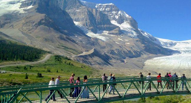
The glacier is a 7-km (4½-mile) tongue of ice flowing from the immense Columbia Icefield almost to the Icefields Parkway. A century ago, the ice flowed over the current location of the highway; signposts depict the gradual retreat of the ice since that time. Several other glaciers are visible from here; they all originate from the Columbia Icefield, a giant alpine lake of ice covering 325 square km (125 square miles). Its edge is visible from the highway. You can hike up to the toe of the glacier, but venturing farther without a trained guide is extremely dangerous because of hidden crevasses.

Athabasca Glacier Ice Walks (800/565–7547, www.icewalks.com) conducts three-, five-, and six-hour guided walks costing from C$115. Reserve a space at the Columbia Icefield Glacier Discovery Centre or through Jasper Adventure Centre (780/852–5595 or 800/565–7547, www.jasperadventurecentre.com) in Jasper. You can also visit the Glacier Skywalk, a glass-floored lookout with incredible views. Tickets for this are also available at the Discovery Centre, as well as on line.

Angel Glacier

Stretching along the north face of Mount Edith Cavell, this glacier was named because it looks like an angel with wings. The best views of the glacier can be seen on the Cavell Meadows Hike.

Angel Glacier, Jasper National Park, Alberta, Canada

Jasper Lake Sand Dunes

The only sand dunes in the Canadian Rockies were formed during the last ice age and are constantly being reshaped by wind. They sit along the edge of Jasper Lake, which is not really a lake as it's part of the Athabasca River. The river widens and you can wade out very far on its sandy bottom; it's particularly popular on hot summer days. There's also a large roadside pullout and toilets. 

Jasper Lake Sand Dunes, Jasper National Park, Alberta, Canada

Recommended Fodor's Video

Maligne Canyon

The Maligne River cut 50 meters (165 feet) deep through limestone bedrock to create Maligne Canyon. An interpretive trail winds along the river, switching from side to side over six bridges as the canyon progressively deepens. The 4-km (2½-mile) trail along the canyon can be crowded, especially near the trailhead. Just off the path, you'll find the Maligne Canyon Wilderness Kitchen and a nice gift shop. On a wintertime ice walk, the views from the bottom of the frozen canyon are spectacular.

Maligne Lake Rd., Jasper National Park, Alberta, Canada

Sulphur Gates Provincial Recreation Area

The place where the Sulphur River meets the Smoky River was formerly known as Hell's Gate. Lookout platforms at this site offer beautiful views. There is a 15-site campground, two equestrian campgrounds with corrals, and two equestrian day-use sites. This site is the main access to Willmore Wilderness Park.

Sulphur Gates Provincial Recreation Area, Alberta, Canada

Yellowhead Lake and Yellowhead Mountain

This long narrow lake was named for the nearby pass. It's 5.6 km (3.5 miles) long and sits at the foot of Yellowhead Mountain, a stunning 2,458-meter (8,060-foot) peak. The mountain has four officially named summits: Bingley Peak, Leather Peak, Lucerne Peak, and Tête Roche.

Yellowhead Lake, Mount Robson Provincial Park, British Columbia, Canada